
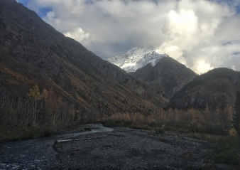
Bashful (pictured above) is the tallest peak in Chugach State Park, coming in at 8,005′. That might not sound like a lot, but the climb starts at ~1,200′. That’s ~6,800′ of elevation gain! The peak is located at the back of Eklutna Lake, a glacially-fed, turquoise finger lake in the Anchorage area. This gorgeous lake is rimmed with dramatic, rugged peaks. We took three separate trips down to Eklutna to hike/bike/climb. Being that I was living and working an hour northeast of Fairbanks, this wasn’t a little trip. If we obeyed the speed limit, the drive took about 8 hrs. On several occasions, we left after working. So we would get to the trailhead already dogged.
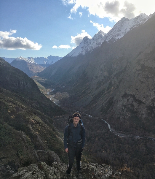
To get to the peak, we followed the bike/ATV trail around the lake (10.5 mi.) From there, we ditched the bikes and hiked in about 2 miles on the East Fork Trail. This beautiful, calm strip stayed constant for each trip.
For the first trip, we (my friends Nate, Trey, Natalie, and myself) borrowed three bikes from the place we worked, Chena Hot Springs Resort, while Trey brought his own (much nicer) bike. We disassembled two and crammed them in Natalie’s little Subaru along with all of our gear. The other two got strapped to the top with ratchet straps. There was just barely enough room for the four of us to fit, with one of the seats laid down. I drew the little straw and had the joy of sitting in the middle seat up next to the bikes on the way down. So this automatically made for an amazing 7ish hour drive.
Now, to be clear, the borrowed bikes were kids “mountain” bikes, with tiny little wheels and even tinier little seats. We arrived about 2 or 3 AM the night before and camped by the parking lot. The following morning, we got up about 8 and unstrapped/reassembled the
bikes. Because we’re intelligent people, we didn’t really check out the bikes until we got to the trail. One had a bent rim. The brakes just didn’t work on two of them and barely worked on the bent rim. They had jacked up shifters that would occasionally shift, but would more often throw the chain off, particularly when a hill was involved. And to top it off, these bikes had no shocks. If the scenery weren’t so beautiful, we probably would have torn each others’ heads off. Our surroundings were about the only thing keeping us going and moderately sane by the end of, quite possibly, the worst experience I’ve had on a bike. When we reached the end of the 10.5, which took ~2x as long as it should have, we were all walking our bikes.


Before starting the hike part of our approach, we stashed the bikes in the scrub near the trail. It felt so good to throw that torture device in the weeds.
We set off down the East Fork Trail, following a route description that I had found online. Where we were supposed to follow the trail for 2 miles before turning up a dried-up stream bed toward Striver’s Gully. Well we hit the cairns for the turn in no time and thought that there was no way that we could have gone far enough. So we kept on moving. We didn’t see anymore cairns after that. We did, however see a massive waterfall cascading off 100-200′ cliffs. (There will be a later story about these cliffs from our last trip to Bashful.) So, after getting some water, we turned around and headed back to the first, and only set of cairns we saw off the trail. By the time we made it back there, it was already about 11 AM, far too late to make any serious push for the summit.
When we arrived back around the turn for Striver’s, we decided to just head up the hillside (more of a scree field starting to be overgrown by alders, devil’s club, and wild roses). At the base of the scree, there’s a tiny little pond that would serve as our guide back down. So, from the pond, we headed straight up the scree bank toward a series of terraced cliffs, each being roughly 20-50 ft high. Nate and I decided it was a pretty good idea to just climb these.
We only climbed about 2000′. We were hoping that we could possibly run into the route we were planning on taking, that didn’t happen. Now, the climbing wasn’t technically difficult, but the Chugach mountains are constructed of a material that is lovingly called Chugach crud. This stuff is jagged and crumbling. We had to check and recheck (yank on) holds before trusting any weight to this disintegrating young rock. Many times, seemingly solid holds would come off in my hand.
After making it up one face of crud, we would be greeted with a small relatively flat section filled with a tangle of ropey, sprawling alders and everyone’s favorite plant, devil’s club. The dead stalks of the devil’s club were covered in slender ¼ to 1 inch thorns that would break off in your skin with the slightest contact. The worst part of these, was that you can’t step on the devil’s club to break it. As soon as you step off it, it would come flying up. After every trip, I would be left using a knife to pry bits of thorns out of my hands. (Definitely got some weird looks doing this at work the next day.)

We eventually reached a little rock platform in mid afternoon, checked our elevation, and it really sank in that we’d have to take another trip to Bashful. Now, the way up was pretty sketchy, so I was lamenting the descent. The times that I slipped on the ascent, my stomach hit the valley floor. I had to use alders as ropes to haul myself up, sometimes missing for devil’s club. We didn’t have helmets, much less any sort of rope, so I was thoroughly relieved, when we found a passable chute to avoid all of that down climbing.
We didn’t gain too much elevation, but the views were gorgeous the whole way.


